
Since I am writing this post, it means I got into the 2014 Hardrock 100. As any die hard ultra runner knows, half the battle is just getting through the lottery. There are three lotteries for the 140 slots for the race. There is a first timer with 35 slots, veterans (5+ finishes) 35 slots, and everyone else 70 slots. The everyone else are for racers like myself who have finished the event 1-5 times.
When the lottery finally occurred, I found myself 10th on the wait list. Over next several months until Memorial Day, I patiently waited as people began to drop from the race until I got my call from Dale the race director.
When the lottery finally occurred, I found myself 10th on the wait list. Over next several months until Memorial Day, I patiently waited as people began to drop from the race until I got my call from Dale the race director.

This race has become an obsession for me. Leading up to race day I found myself thinking through the race and all the climbs, yet despite having done the race in 2011, it is still far more challenging then I can remember. I won't go through all the stats of every climb like I did in my 2011 race report yet in summary the near 68,000 feet of elevation change only gives one aspect of the challenge. The climbs and descents are mainly technical with over 12 miles of open terrain navigation which is especially challenging at night.
My feet were wet almost the entire race despite changing socks and shoes. I crossed hundreds of streams and rivers (I even tried counting but gave up after 100 by mile 40) all being refreshed with daily thunderstorms. I found myself in rain twice on Friday and it rained half the day on Sunday - yet not as bad as 2011. Finally there was plenty of sections with mud and snow.

Thursday was the briefing and check-in day which was held in the high school gym. It was a who's who of ultra runners. I got to meet and get my picture Kilian Journet, (see below) the eventual winner, and saw many other elite runners at the event that were either pacers or just to watch. Personally, as looked around the gym I couldn't help but freak out knowing how good all the runners are. If it wasn't for finishing in 2011, I would have felt I was out of my league.


The start at 9,310 ft would seem slow to most observers as even the elites trotted out of town and even on the first hill racers began to power-hike. The first few miles is the only part of the event that would feel like a "race" with everyone close together.

The weather in the beginning was great with partly cloudy skies and when we got to the river it was a non-event. The river was only about foot deep with a light current. In 2011, we did the superman because the current lifted us off our feet as we hung to the rope for our dear lives.

After a short runnable section, the route turned south and began a long steady climb up the Bear Creek Canyon (note there are multiple Bear Creeks in the race). I was feeling really good in this section and I enjoyed seeing it in the daylight. There was a few rocky sections and few quick steep sections yet it was the easiest climb of the race.


In about 5.5 miles we reached Putnam Basin which had several ledges and a barley noticeable trail that eventually hit the Putnam-Lime Creek saddle then to the summit of the first climb at 12,600 ft.


Below: looking back at the hike up


Below: Top of the saddle and the summit to the right


Descending down the first climb is navigated by following other runners or the course flags as there is no real trail. The target is the saddle pictured below. At this point, I had a few fast downhillers fly past me to the next short climb on the other side of the saddle.


After crossing over the Lime Creek Saddle we dropped into the Porcupine Creek Drainage. This section easy to follow in daylight on the sheep trails. It was steep at the beginning and then it moved into a good section through the trees with a few bogs.
I have to reflect on this part of the course back in 2011. It was dark with heavy thunderstorms that made the trail into a muddy mess that the was very hard to follow. It took us four times as long to complete this same section as to compared to 2014.


At mile 10.5 to 11, the route opened up into the South Fork of Mineral basin. There was some mud and bogs down to the creek that was easy to cross and it cleaned the mud from my shoes.


Looking back

KT Aid-Station Mile 11 at 10,600 ft

Leaving the aid-station, the route followed an old mining road around a horseshoe to the Ice Lake Basin creek for some great pictures as runners balance themselves across a natural log bridge.


After crossing the creek, I got on a well traveled trail that leads people to Island Lake and the Ice Lake basin. There were lots of hikers and runners not in the race cheering us on as we made the steep hike past Island Lake up the saddle of Grant-Swamp Pass.

The next round of pictures are on the climb up and over Grants-Swamp Pass (12,920 ft). I love the views of Island Lake (below) and on top seeing the next climb - Oscars Pass. As I was making my way up, I began to feel weakness in my legs despite fueling and hydrating well especially with only 14 miles into the race. I wasn't concerned and figured it would disappear after some time.


The Joel Zucker Memorial. We got to meet Joel's sister from NY on 4x4 drive Thursday Morning

Below is Oscars which would be the third climb after descending to the valley below.

The view below is the famous Grant-Swamp Pass scree field. This may seem obvious, going down was easier this year then going up in 2011. I know people who hate going down this stuff yet for me it is like skiing. With the scree being wet, it cut down on the dust and it clump together as I slid down the section.

I reached the Chapman aid-station (10,190 ft) just after noon. I refilled my bladder and ate some food to begin my 3,000 ft climb. Oscars is mainly on a closed jeep road that reaches the summit in just three miles. I was still feeling the same in my legs yet I was able to get a good cadence climbing. I pushed hard for nine minutes and rested one minute which allowed me to climb 300 ft every 10 minuted segment. It rained a few minutes but it was no big deal.


At the top of Oscars (13,140 ft) the view turns north to Bridal Veil Basin which was the route used in 2011 but this year we turned left over a saddle that would go into Wasatch Basin. The next twelve pictures are of the six mile descent through the basin to Telluride. I loved this section, the skies cleared and as you can see in the pics it was best of the Rockies. This is a must do hike for anyone visiting Telluride.


Just before 4:00 pm, I arrived in Telluride (8,750 ft). Think about this - TEN hours of racing and I covered only 28 slow miles. I took some extra time to eat, rest, and use the restroom before leaving. I was tortured by being on pavement for a half mile before again hitting the long trail/jeep road section up out of the valley.
The climb out of Telluride is long and gradual yet ideal form my style of power-climbing with my trekking poles. The problem is that my legs felt like jello and not just fatigued. I wasn't climbing; I was crawling with a strange flashes of pain in my left thigh. It continued all the way up and I began to rethink my ability to do the race because this pace would be unsustainable for another 70 miles. I even called Kelly to let her know about the situation and that the race was in jeopardy.
I pulled off to sit on a rock to give my legs a break. As I was resting, Scott who has finished this multiple times stopped to talk with me and he did all he could to lift my spirits and encourage me from quitting. Mentally, I was "60% quit - 40% keep going" but no matter what I had to finish the climb and make my way to Ouray.
Liberty Bell Basin

Just over the Mendota Saddle looking up to Virginus and the Kroger aid-station

The next six pictures are of Krogers Canteen aid-station at mile 32 (13,100 ft). This the most unique aid-station of any race. It is set up by mountain climbers who carry up all the gear and set a rope for racers to descend the other side. I had a popsicle and a quesadilla while resting my legs before descending. At that point I was 70/30 on quitting but at least I had a down hill all the way to Ouray.


Coming off Krogers was the most fun section of the race. I had rope descent for few hundred feet yet there was still a half mile steep descent in the snow. I could see where some racers just slid down on their butts and by accident after falling I did the same.
Below is Amanda Grimes who had the honor of bing the final finisher

View down to Governor Basin and the snow trail

Shortly after the snow section, I was on a fast moving road for another mile to the Governor aid-station (9,693 ft). I was still questioning my future ability to finish the race yet I still took time to change into some dry socks and added lubricant to my blistered feet.
In the few minutes that I was at the aid-station it had turned dark so on came the headlamp for the trot down Ouray. On the way down I was able to do a slow run on few sections yet my legs still felt bad.
In the few minutes that I was at the aid-station it had turned dark so on came the headlamp for the trot down Ouray. On the way down I was able to do a slow run on few sections yet my legs still felt bad.
I arrived in Ouray (7,870 ft) around 10:45pm, way after my goal of arriving around 8:00 pm. I told everyone that I was really thinking of dropping. I asked what I need to do if I dropped and Brad, the aid-station Captain, asked what was going on and I said my legs were tired and felt like jello. He said, "I have never heard that before. Go get something to eat and maybe a message." I agreed to wait a few minutes. I shared what was going on with John, Marcy, Kelly, and my friend Liz Sanchez who was volunteering at the aid-station heard what was going and volunteered to give me a message.
Liz dug into my muscles with Arnica lotion as I ate some food. As the message went on, my legs began to feel better and everyone was still willing to continue knowing we were going to have a late finish.
Feeling better from Liz's magic hands, I made the decision to push on!
I changed into some fresh shoes and socks and then John and I marched out of the aid-station to begin our trek out of town. At the same time Kelly and Marcy waited long enough to make sure we didn't turn back before the long drive back to Silveton.
The section between Ouray and the top of Engineer is the longest continuous climb in the race yet the most annoying part is the three mile section along the ice park trail in town with a bunch of ups and DOWNS. It started to rain on us at the edge of town and it lasted for 40 minutes until we finally reached the Bear Creek trailhead for good weather through the remainder of the night.
For the second time running Hardrock, I would miss seeing the impressive Bear Creek canyon and the steep ledges along the trail. This would scare many people in the daytime and for me it is just a trail with dark abyss to my side. Below is a picture of Bear Creek that my friends Sean and Laura Wetstine took the next week on training run.

As for my legs they were in great shape and I was able to climb normally again. The trail through the canyon meandered high along the cliff until eventually it got to the river level, which of course meant we had to cross it about five times before reaching my second favorite aid-station - Engineer at 3:20 am.
Engineer is an eight mile 4,000 ft climb from Ouray. We warmed our feet by the fire and ate some soup and drank some Coke before quickly leaving to finish for the remaining 1000 ft climb to Engineer Road (12,910 ft). After reaching the road it was down hill for the next five miles. I was able to maintain a slow run and my legs were still feeling good but the blisters on my feet were bugging me.
We arrived at Grouse Gulch (10,710 ft) just after 6:00am where Marcy and Kelly were waiting. I was hoping to change into some fresh dry shoes unfortunately my other pair were still wet from the previous day. This is lesson for future Hardrocks to bring more then two pairs of shoes. I did spend some extra time eating and applying more arnica lotion to legs to make sure I was prepared for the next 42 miles.


Leaving the aid-station, Kelly joined me as new pacer for the next 16 hours and 34 miles. She was pretty excited knowing that she was about to bag a new 14er (Those outside of Colorado - a mountain over 14,000 ft).
We began with a steady switch-back climb up an old jeep road up to American-Grouse Pass (13,020ft) into American Basin. I wish had more pictures except my camera died and Kelly's was packed away. On the way up I had a real good pace that even allowing me to pass a few racers. After the three mile trek across American Basin there was another climb up to Handies Peak (14,048 ft).

View from the top of Handies from 2011

The next four miles was on a good dirt road that had a gradual descent. We were able push in a slow run and make some good time down to the Sherman aid-station (9,640 ft). When we were half mile away we had to pull out our rain coats due to a good rain shower before arriving at just after noon.
The road to Sherman


At Sherman, there was plenty of cover from the rain so we got under the tent to stay dry while I got one of the medics to work on my feet. I had several blisters that had burst and skin had worn off - I guess that was a good thing. To help my feet, we cleaned them off and let them dry for a while before bandaging and duct taping them.
At 12:37 pm, we pulled out of Sherman and began the climb to Pole Creek. It continued to rain for about 15 minutes before it cleared up. Unfortunately that would be short lived. About 30 minutes later, the clouds came back in and it ended up raining on us the next several hours.
For about five miles we climbed up to 12,200 ft at Cataract-Pole Divide pass. Along the way there were several creek crossings. I tried to keep my feet dry but it was hopeless and, to make things worse, we ended up traversing several mile through marshy/swamp areas. As we got closer to Pole Creek, I kept thinking it was around the bend yet I was wrong numerous times.
Note the next eight pictures are from 2011 since our cameras were dead. The first three, the clouds and scenery were identical to 2014.
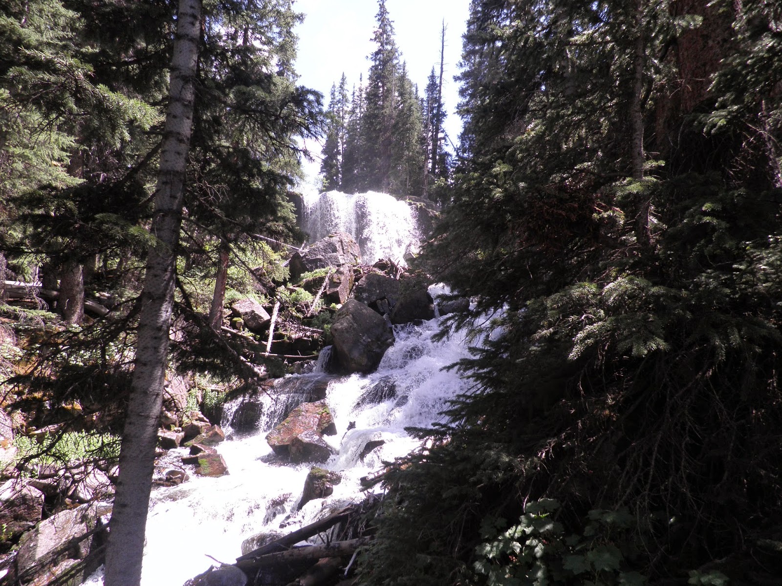
Waterfall about 2 miles from Sherman
Cataract Lake

The Swampy Mess

The next 3.6 miles only had 1,000 ft climb but the mud holes, thick willow, and numerous creek crossing didn't make it any easier. Eventually we reached Maggie-Pole Pass (12,530 ft). Following the pass we dropped nearly 1,000 ft in one mile to the Maggie aid-station (11,640 ft) just before 7:00 pm.
At this time my pacer Kelly had been on the trail for 13 hours and we both tired. We spent 10 minutes to sit and rest our legs while we ate solid food and refill our bladders. I felt this rest was important because we were starting up one of the steepest climbs of the race.
We started with a few switch-backs but then started going straight up a ridge, yet course flags had us turn right to summit some peak before looping back around. We climbed 1,500 ft in less then a mile to 13,050 ft.
After reaching the top, the trail was great and could have been runnable but my feet were really bothering me. This was really irritating as racers zoomed past us down the hill to the Stoney Pass Road. Below is a picture from 2011 on the other side of Stoney Pass looking at the backside of the climb I just described.

After crossing the road it was getting dark so we had to pull out our headlamps. We had another quick climb over Green Mountain Pass (12,980 ft) as the last glimpse of daylight disappeared. On the other side it was very steep descent at first on a very hard to follow game trail sparsely marked with course flags.
This pic below is what it would have looked like during the day. This is also the scene on the 2013 race poster which I am pictured on.

In the dark, Kelly and I really struggled to follow the trail and flags. All over were bright yellow flowers that looked like the flags to make it even more confusing. We separated ourselves by about 75ft to both try to find the course flags. It would be real easy to go down the wrong side of the mountain so it was very important for us to not get lost. Eventually it became a little easier when the trail became more apparent.
Along the way, we heard a guy in front of us yelling and it ended up being a lost pacer. I had him join us as I tried to follow the trail. It was still difficult to follow and became very steep and technical as it made a u-turn around the mountain. Way below we could see the Cunningham aid-station and lights zig-zagging up on the mountain across the valley. The pictures below show the last climb and aid-station I just described.

We were slowly making our way down the last mile on the trail. It was very steep and potentially dangerous if we lost our footing. Another racer and pacer caught up with us but they thought we were on the wrong trail and going out of the way but I trusted Kelly on this one not to mention it seemed to be same direction I came up in 2011. At this time I started to feel the signs of sleep depravation. I was awake but it was hard to focus on the trail but finally we got to the road and John and Marcy were waiting for at the Cunningham aid-station (10,380 ft). In the picture below is Cunningham (again from 2011). Across the valley is where we had to scale down in the dark in the section to the right of the waterfall.

At the aid-station, I quickly ate some food and got a new headlight to begin the last leg of the journey. My feet were killing me with blisters and also my toes were beaten up from banging against rocks from the entirety of the race. So every time I slightly stumped my toe it really hurt.
Just after 11:00 pm, I got Marcy as my new pacer which was perfect. She ran this section the same day in daylight the opposite direction and knew step and turn to the finish. She guided me as I began to move into semiconsciousness. The climb up was steep with many switch-backs. I led the way setting the pace with a solid march yet I was barely there mentally. I kept talking with Marcy yet I was seeing things that weren't there such as trashcans in the bushes and rolls of toilette paper. Rocks would look like different things too and Marcy kept a mental log of all the things I was describing. To try to stay awake, I took in GU Roctane with caffeine every 30 minutes which was more than normal but it was needed.
In just two miles we made it to the Dive-Little Giant Pass (13,000 ft) and we were done climbing. We then had quick traverse before descending down. I hated the first mile down. It was steep, rocky and lots of scree that killed my feet.
We finally got to a road section where I was able to pick up my pace until we got to the bottom. We had to cross the river a final time before joining a trail that paralleled the Animas River to Silverton. Again, I really appreciated Marcy knowing where to go because it would have been hard to make all the correct turns.
Finally, just after 4:00 am we made it to town and we called Kelly and John to wake them up. We proceeded through what felt like a ghost town to the high school. At 4:23 am and 46 hours and 26 minutes of fun I crossed the line kiss the Hardrock!
Following the finish we went into the gym where I immediately pulled off my shoes and socks to see my feet. They were swollen and water logged with blisters. Liz Bauer, who set the record for the most 100 milers in one year, said they were the worse feet she has ever seen. I believe they started to look better after they dried out.
Below is a video I made on the top of Grants-Swamp, Oscars, and Handies.


I was only able to drink half my beer before crawling into the jeep for a few hours sleep. Around 8:00am we woke up to get some coffee and let my parents know that I finished before going to the awards ceremony.
At the ceremony, Dale, the race director, always shares a personal story about each finisher. This year Kilian broke the record and even more impressive Kirk Apt was honored for finishing the race 20 times! He actually received the large poster signed by all the racers.
Hardrock is a special race. It is challenging to describe how hard the course is and I will continue to add my name to the lottery on a yearly basis.
Below are my Garmin readings for miles 1-50, 50-86, and my ugly feet.

