

Hardrock is the most challenging 100 mile mountain race in America and arguably the world with nearly 67,000 ft of elevation change mostly in altitudes between 10,000 ft & 13,000 ft with a highpoint above 14,000 ft. It is mostly single track with many rough sections. 2011 would add extra challenges with late winter snowpack producing added runoff. Also, this year runners would experience an early aggressive monsoon season that provided numerous flash flood storms.
I learned about the Hardrock 100 ten years ago at the prerace dinner for the Sunmart 50K/50M. I was wowed learning about the great feats from the seasoned runners and the one guy who had run a 100 miler said Hardrock was the hardest and most prestigious race in America. At the time I was hoping to finish my 50K since it was my first ultra and I had never even ran beyond 22 miles. Since that first ultra I have dreamed of some day running this great race.
Nearly ten years later and with 30 marathons and 29 finished ultras including five 100 milers (Bighorn, Wasatch, Western, and Leadville 2X) under my belt, I made the lottery for the 2011 Hardrock 100. To prepare for the race I kept a regular spring race schedule doing three 50ks, two trail marathons, and one road marathon. As for weekly training I did the best I could with 80% travel schedule maintaining a 40-50 miles a week (my preference is 70 miles a week).
To build my endurance base I had a 110 mile capstone week that include 12 mile rolling trail run (in Akron OH) on a Friday, 16 mile foothill run (Mathews/Winters Park in Jefferson County, CO) on Saturday, and 50K flat gravel trail run on Sunday (the Highline Canal in Denver). Then the following week I did the 6 day Ride the Rockies.
Below are the highlights of my experience running the 2011 Hardrock 100 starting with a video overview through the race:

Silverton – Cunningham Gulch
Segment 0 - 8.6 miles/ Total 8.6
Climb: 3,840ft / Descent 2,770ft
Cumulative aid station time: 4 mins
Time – 6:00am – 8:49am Total 2hrs 49mins
The race began at 6:00 am next to the Kendall Mountain Ski Area in Silverton CO. I started about 20 ft from the front, which allowed me to see everyone and even a few elite runners. As the race started, I quickly dropped to the middle of the pack as we rolled along the hillside above the Animas River. The weather was great and I enjoyed visiting with all the other runners as we made our way north before the big climb. Even at the beginning, it was clear my feet would remain wet through the journey with all the stream crossings.
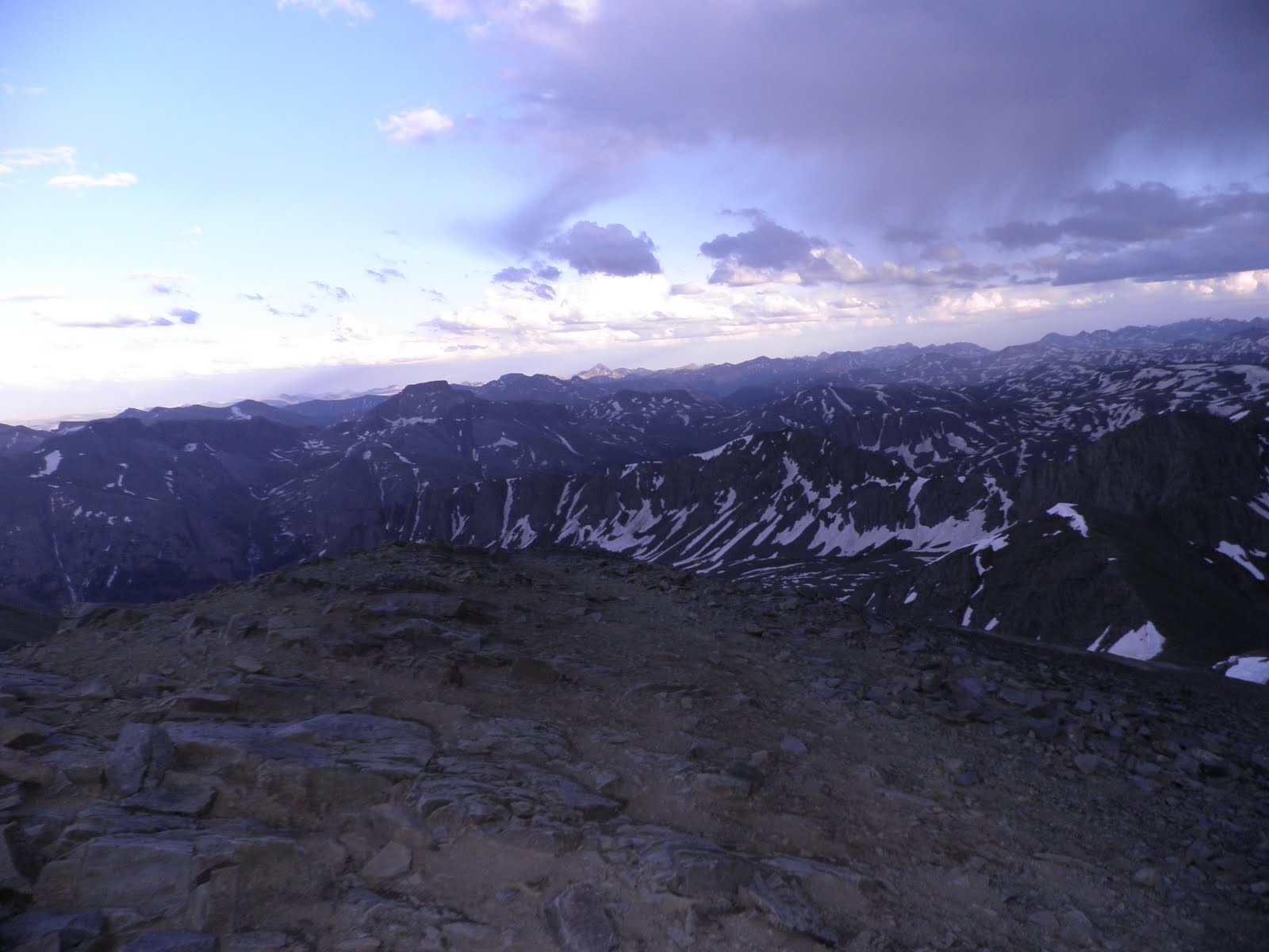
About 3 miles into the run, I turned east crossing a river and moved up a jeep road and then eventually joined a single track into the Little Giant Basin. The trail passed the Mayflower Mine and the aerial tram that went to the Big Giant Mine. As the trail continued to climb above tree line, runners hit their first patches of snow yet it was nothing compared to later. The top was the Dives-Little Giant Pass (mile 6.4) at 13,000 ft which provided excellent views back down to the Silverton/Animas valley.
The next 2.2 miles was a steep downhill that first followed game trails then some switchbacks to the Cunningham Gulch aid station. This would be the only stop until many hours later that I would see my crew (and future pacers) Kelly Goode, Jason Mittman, and Shauna Metcalf. I also enjoyed keeping up with Marcy Beard’s progress from her crew (John, Kathy, Ann, & Scott). Kelly filled my bladder filled as I grabbed some solid food. Then I said my goodbyes, and departed at 8:45 am.


Cunningham Gulch – Pole Creek
Miles 8.6 - 19 / Segment 10.4
Climb: 4,120ft / Descent 3,040ft
Cumulative aid station time: 5 and 3mins (2 aid stations)
Time – 8:49am – 12.51pm Total 6hrs 51mins
Now it was time for the next big climb and physically I could already feel the strains of the race, yet this was just scratching the surface of what was to come. Mentally, I was as solid as a rock and having a great time.
I began a steep switchback climb up out of the valley using pack trails to the elevation of 12,600 ft. I enjoyed the morning sun, the wild flowers and the spectacular views. After climbing for a while I reached the Green Mountain Basin, which I followed up for a few miles. It was a clean trail with only a few boggy/muddy sections due to the snowmelt. I then made a quick climb up the Stony Pass Ridge to just under 13,000 ft where there were a few spectators.
Leaving the ridge, I had a 500 ft descent through some scree until I crossed the Stony Pass road which is near the headwaters of the Rio Grande. On the other side of the road, I had a manageable climb to the top of the 13,165 ft Buffalo Boy Ridge (mile 13.1) which provided some of the best views of the race. To the south were some massive granite peaks in the Grenadier range and Weminuche Wilderness. After a few pictures and crossing a snowfield, I had quick descent and a creek crossing into the Maggie Gulch aid station (mile 14.7) at 11:25 am.
Leaving the aid stop, I made my way up the 500 ft climb (climb #4) to 12,530 ft Maggie-Pole Pass to enjoy another runable section into the valley with lots of willows and few stream crossings, which are headwaters to the Rio Grande. This would be the only time in the race to see Marcy as she passed. By 12:30 the wave of storms hit so it was time to put on my Golite jacket and continue to make my way to the Pole Creek aid station (mile 19). At the aid station, the rain had moved on and I was able to remove the jacket and enjoy a quick bite before I took off again.
As for gear and clothing, the following is what I wear and carry on the race:
- Headsweats running hat
- Moeben arm sleeves
- Hightech shorts sleeve running shirt
- Mountain bike gloves
- Patagonia or Brooks trail running shorts
- Compression calf-sleeves
- Drymax trail socks with Hydropel on my feet
- LaSportiva Trail shoes with their great toe guards
- REI Carbon Trekking Poles
- Ultimate Direction Wasp pack with 100oz bladder
- Golite waterproof/breathable shell
- 8 Gu Roctanes plus three reserves
- Ziploc bag with Sportlegs, Advil, & ginger candy
- Camera
- Spare pair of Drymax socks
- Tube of Hydropel
- Duct tape
- Ziploc with toilet paper
- Headlamp
- Spare batteries
- ID and cash
- Phone


Pole Creek - Sherman
Miles 19 – 28.1 / Segment 9.1
Climb: 1,390ft / Descent 3,210ft
Cumulative aid station time: 11mins
Time – 12.51pm - 3:51pm Total 9hrs 51mins
Leaving Pole Creek I had a few up and down sections that crossed back-and-forth across the river as I made the way up the valley. The first few miles were runable with only the distraction of few rain showers. After taking a hard left off the main trail, I had to follow pack trails and course flags. Keeping a close eye on the course flags can be a challenge even during the day. As I moved along with another runner we lost track of the flags and discovered we were 200 yards off the course.
Eventually I gained another 500 ft to the summit of Cataract-Pole Pass (mile 22.9) on the Continental Divide at 12,200 ft. I was able to enjoy the view of Cataract Lake below and the long valley that I was about to descend. Overshadowing the entire view was Sunshine Peak (14,001 ft) and 3,000 ft below at the base of the peak would be my next aid station.
The next 5 miles would be my fastest section of the race. The first few miles were still above tree line with a few stream and snowmelt crossings. Along the way, I saw runner lying on the ground in a very relaxed position. I debated checking on him, but since it was early in the race I choose to keep my mouth shut and allow him to rest.
As I moved into the trees there were numerous waterfalls along the Cataract steam which I crossed numerous times. Later the sleeping runner caught up with me and said he was fine but just need a few minutes to rest from the altitude. At the bottom, I crossed a metal bridge over Cottonwood creek to the wonderful Sherman aid station.
Sherman was the only location that I had a drop-bag. I put on sun block and reloaded my Gu Roctane while enjoying the personal service from the volunteers and some warm solid food.


Sherman – Grouse Gulch
Miles 28.1 – 41.5 / Segment 13.4
Climb: 5,258ft / Descent 4,188ft
Cumulative aid station time: 15mins
Time – 3:51pm – 9:57pm Total 15hrs 57mins
This section started with a 1/4 mile road before a sharp climb through private land before joining the Cinnamon Pass. I remained on the road for 3 miles trying to run the flats and down hills. There were a few cars and ATVs on the road that shared their dust with me and the other runners.
When I reached the Burrows Park turn off (mile 32), I utilized the restroom and then crossed the bridge to begin the big climb. Before I got going, one of the international runners stopped me to ask a question. The only problem was she did not speak English and I did not speak her language. I think she did not believe she was on the correct trail from pointing up the trail and shaking her head. I tried to show her the flag on the bridge and the flag at the beginning of the trail. Since the trail up Handies Peak was a closed trail there was not going to as many flags going up. I hope one of the next runners could help her but I had to go.
The trail would be easy going with good conditions and switchbacks through the trees until I made my way into Grizzly Gulch looking up at Handies. At this point, I had been racing for 12 hours have covered 34 miles.
The last mile to the top was covered with snow yet it was easy to follow the tracks of other runners. Closer to the top, I enjoyed watching some college kids slide down the snowfields on their jackets. At mile 36.2, I reached the top of Handies Peak (14,048ft) at 7:30pm and took some pictures and video and began my run down the backside.
On the downhill run I watched the sun setting into a patchwork of storm clouds. Looking ahead the American Basin section appeared challenging because all I could see was snow fields and a large frozen lake. As I crossed the snow, it ended up being easier then I anticipated since it was not frozen. Before I knew it I began the climb to the Grouse-American Pass.
As I got within 300 ft of the 13,480 saddle with three other racers a bad thunderstorm rolled in. We debated on what to do: go back down, find higher rocks, or go for it. We decided to make our way to higher rocks. Nearing the higher section, we dealt with lots of lightning, rain and hail so the other two runners decided they could make it over the pass before it got worse. I decided to go with them and the lightning scared me enough to make this my fastest section of the race. I had no desire to become a fried trail runner. Even after the storm passed, I kept a good pace and quickly I could see the neon lights of the Grouse aid station in the Animas River Valley.
It was nearly 10pm and I had not seen my crew since before 9am. This is how crews really earn their keep having waited for me for over 13 hours. I felt bad and even offered to give them a pass on meeting me in Ouray because of the late hours and driving over Red Mountain Pass. That would have nothing to do with that idea and insisted on making the journey.

View of the Cataract basin as I began my climb up Cinnamon Pass


Grouse Gulch - Ouray
Miles 41.5 – 55.9 / Segment 14.4
Climb: 2,765ft / Descent 5,795ft
Cumulative aid station time: 8 and 20mins (2 stations)
Time – 9:57pm – 4:16am Total 23hrs 16mins
For the next 5.4 miles the race would follow the jeep road up Engineer Pass with diversion to Oh Point (12,910ft). I had to deal with a rain most of the way up but there was no lightning. I enjoyed hiking past the snow banks and looking back at the other runners. I was able to follow their headlamps zigzagging up the jeep switchbacks behind me. Shortly after Oh Point I would begin the long down hill.
This section had its challenges: numerous river crossings, snowfields and slick boggy sections. In the beginning, there was not a real trail so I had really concentrated on following the reflective Hardrock flags. At mile 48, I reached the Engineer aid station to enjoy a warm fire and refill my bladder.
I remember one volunteer asking “How can you stand to run this night section without a pacer?” I love night running, I feel connected with nature, it clears my head, and I love the adventure. Before leaving, one of the volunteers warned of high water and strong current at the upcoming Bear Creek crossing.
Leaving began with a steep drop through some deep snow before reaching the creek. It was waist deep with a modest current that I felt comfortable crossing two times. The trail began to rise up above Bear Creek and the canyon began to tighten up. For the next few hours, I ran without seeing any other racers. The only life I experience was a few deer and a grumbling sound in the trees above me. Not sure what it was, I began to clank my trekking poles and kept looking back. No, I was no hallucinating, that would come in another 24 hours.
As I moved down the canyon, smart foot work became important with steep cliffs to my left. I knew the river was 300 ft below and I could hear it roaring in the canyon below. Eventually, I reached HWY 550 and I was able to call Kelly and let her know I would be there soon.
The next 3 miles to the Ouray aid station was annoying. You could see the lights of town yet the trail seemed to zigzag up and down on the other side of the highway. Eventually, I made it into town to see Jason walking up the street. I followed him through town until we reached the aid station.
I took a little extra time to eat some food and then I drank a bottle of protein rich recovery drink and some Starbucks for the added caffeine. I knew that I would be free of river crossing for a number of hours so I changed into some dry socks and into LaSportiva Electron shoes. To be prepared for the challenges of Virginius, I also packed some warmer gloves and my Yaktrax. Again, it was nice to see Kelly, Jason, and Shauna.


Ouray - Telluride
Miles 55.9 – 72.1 / Segment 16.2
Climb: 5,508ft / Descent 4,438ft
Cumulative aid station time: 7, 5, and 15mins (3 stations)
Time – 4:16am – 11:35am Total 29hrs 35mins
Leaving Ouray at 4:00 am on a Sunday is like walking through a ghost town. There were no cars, people, or other runners. For the only time in the race - I felt lost. I even pulled out the directions because I thought I was going out on the inbound course. The directions said to go ½ mile and turn right on Queen Street. After running 22 hours it is hard to judge a 1/2-mile and I could not find Queen Street. At least I still had my senses and pulled out my iPhone to use its map. Finally, I was able to make the correct turn.
The route went up a jeep road then through a tunnel and eventually joined Camp Bird road. I would continue up the road along side Sneffels Creek while enjoying the sunrise. At 24 hours, I caught a few runners who just woke up from quick nap. I enjoyed their company until I pulled over for a pit stop at a forest service restroom.
Eight miles and 3,100 ft later, I reached the Governor Basin aid station (mile 63.8). I refilled my bladder and enjoyed a yummy sausage, egg, and cheese breakfast burrito with a cup of OJ.
Side note on nutrition and drinking: I made a point to drink every 10 minutes which is one of the keys to successfully finishing a 100 miler (or any other distance race). I would keep my bladder full with either the supplied or my own sports drink while drinking water in the aid stations (a good sign of drinking right is urinating hourly). For food, the aid stations are my only source for solid food. I would eat what sounded good at the time (PB&J, Fritos, watermelon, soup, pasta, turkey, ect.). Every hour I would take one of my GU Roctanes (unless I was eating in the aid station). Finally, I would take Sports Legs every half hour or before a big climb.
Back to the race, I departed the aid station and began my march up the Virginius Mine road. I followed the switchbacks up the mountain until it became blocked with snow and then followed the tracks of the previous runners. In the race briefing, runners were warned about the conditions in this section, so I put on my Yaktrax and gloves. My only issue is that I brought one of my tracks and one of Kelly’s, which was smaller. After some adjustments, I was able to get hers to fit.
The route went up a snow trail then across some dry rocks and then it repeated the same again. When I reached the bottom of the gully, the remainder of the climb was very steep completely covered with snow. I was also being blinded because I left my sunglasses with crew in Ouray. This lasted for a few hundred feet until I could see Virginius pass and the volunteers perched on the ridge.
Now the fun began. They a long rope dropped off the pass for the runners to pull themselves up. I locked my trekking poles into my pack and began the steep rigorous rope climb to the top. After a few stops to get my breath, I finally made it (13,100ft & mile 67.1).
Hanging on the edge of the Pass was Kroger’s Canteen staffed with mountaineer volunteers. Considering their location, I was not expecting much yet I enjoyed my favorite meal of the race. I had yummy quesadilla and great company.
With the advice of one of the volunteers who was about to shuttle trash to Telluride, I kept my Yaktrax on for another half mile. I made my way down the steep scree-field and around the snow covered Mendota ridge where I could then remove them.
On the other side of the ridge I made my way down across a valley and eventually got into the trees which followed the old Liberty Bell jeep road to town.
I gave Kelly a call to let her know what I needed at the aid station. When I reached town both crews were waiting to take some pictures and walk me through town to the aid station.
Beside the usual needs in the aid station, I decided to change into some fresh dry running shorts because my legs were raw due to chafing (yes, I kept apply glide and Vaseline through out the race). I also changed my socks and applied a new coating of Hydropel to my feet to avoid blisters and switched back to LaSportiva Raptors that I used in first half of the race.


Telluride – Chapman Gulch
Miles 72.1 – 83.4 / Segment 11.6
Climb: 4,500ft / Descent 3,090ft
Cumulative aid station time: 10mins
Time – 11:35am – 5:48pm Total 35hrs 39mins
For the first time in the race I would have the company of a pacer. Shauna graciously volunteered to join me through this scenic section. The 2011 race course had changed with an additional 2.3 miles going up Bridal Veil Falls. The route went below and above the falls and then into the high country. We were able to enjoy talking to a few tourists and get some great pictures at the falls.
Before we knew it, it was thunderstorm time again. We put on our jackets and since we were lower in the basin we felt comfortable pushing forward despite the lightning. Later we heard that Marcy and Ann, who were higher up, had to take shelter in some rocks.
Over the next hour we pushed our way up Bridal Veil Basin crossing numerous creeks, mud, and snow fields. We eventually connected with the original course had a final steep snow climb to the top of Oscar’s Pass (13,140 ft & 80.9 miles).
At the top of the pass, I thought we would make some good time down yet the road was covered with boulders and the occasional snowfield. Across the horizon, we could see the daunting next climb to the Grant-Swamp pass and the famous scree field climb at the top.
Finally, 3.2 miles later we made our way down to the Ophir Pass road where both crews were waiting and we walked into to Chapman to switch pacers and get some food for the final 19 mile push.
At the aid station, both crews were worried about our ability to finish in time but I was not concerned. I felt good with the exception of some chest congestion, which was slowing me down. As for motivation, a volunteer indicated there was only one more runner expected in which would put me 2nd to last. With 12 hours and 12 minutes to meet the 48 hour cutoff, we were off.


Chapman – KT
Miles 83.4 – 90.7 / Segment 7
Climb: 2,920ft / Descent 2,450ft
Cumulative aid station time: 13mins
Time – 5:48pm – 10:20pm Total 40hrs 20mins
Kelly blasted out of aid station with a mission but I had to slow her down to get my breathing right and then we had balance. We had one quick rain shower that soon cleared up as we crossed a snowfield moving up Swamp Canyon. After the snow field, we were passed by another runner. Since I could not see anyone else moving up the valley I thought I was in last, which in its own way was motivating, like running anchor in a relay.
In just two hours we reached the steep scree field climb. I would march up in ten step segments, rested and continued repeatedly. Just before sunset we reached the top of the 12,920 ft Grant-Swamp pass. From there, we had to run down the scree field on the other side past Island Lake into the Ice Field Basin.
As it was turningdark, a bunch of fast moving clouds began to blow through including one that dropped off the mountain right into me. We were concerned that there were some strong storms were associated with the clouds so put on our headlamps and moved quickly to a lower elevation.
In the darkness, we began the “Romancing the Stone” section. Kelly named this part of the race because of the similar conditions as the chase scene where Kathleen Turner and Michael Douglas slide down a jungle mudslide. For us, it was the steep drop down to river flowing out of the Ice Field Basin. I slid and fell at least 5 times making my way to river below. I would have been ok sliding to the bottom but the roaring river below made us a little uneasy.
At the river crossing we were joined by another runner (I was glad to see since I feared he may had dropped in Chapman). At the river, there was waterfall above and below with deep fast moving water. I was actually glad to be in the dark, so I could not see what we were going through. We made it and then had an easy mile on level trail to the KT aid station as the storms moved in. There were several runners warming up and enjoying the shelter from the storm.


KT – Putnam Basin
Miles 90.7 – 96.3 / Segment 5.6
Climb: 2,25ft / Descent 1,455ft
Cumulative aid station time: 7mins
Time – 10:20pm – 2:34am Total 44hrs 34mins
After we refilled our bladders, it was time to go and face the pounding rain and make our way up the last climb of the race. We ran down the road for a half-mile and then we had to cross a tributary to the South Fork Mineral Creek. When I stepped in the water it was up to my ribs with a strong current. I stepped out to see if Kelly wanted to go for it. Before I finished asking she was half way across saying “Come On”! There was no rope and to fight the current I made sure I was sideways to have less resistance.
For the next quarter mile, we slogged in deep gooey mud through willows on an unmarked trail until we finally got to a section of steep switchbacks. After navigating around Twin Sisters Peak we dropped into Porcupine Basin with several more creek crossings. We then began another climb with some hard to find sections where we had to backtrack to find the correct route. Eventually we reach Cataract-Porcupine Pass at 12,230 ft (12th pass of the race). We then traversed across a few snowfields to a saddle.
At this point, I mistakenly thought were about to go down but the flags started to go up one more mountain. After being awake for 40+ hours, this was tough and then we saw a bunch of strange lights on mountain above. What we saw were 3 pairs of spinning lights which seemed odd. Below me, another yellow light came up from the saddle and then as it got close I yelled “hello” but then it disappeared. Hmmm. I guess it was some animal with its eyes reflecting off my headlamp.
As we began the final climb, we then understood the spinning lights from earlier. It was other runners and pacers turning their heads back-and-forth looking for the course flags as they moved up the ridge. Finally, we reach the top at 12,600 ft on the Putnam-Cataract Ridge.
The next 1.5 miles was an ongoing process of trying to find the course flags through the Putnam basin until finally we saw the lights of the Putnam Basin aid station.
We refilled our bladders, got a quick bite to eat and I changed one sock and added some Hydropel to a hotspot on my foot. My hope was for some good trail conditions that would allow for some running.


Putnam Basin – Silverton (Finish)
Miles 96.3 – 102.8 / Segment 5.6
Climb: 324ft / Descent 2,614ft
Time – 2:34am – 5:19am Total 47hrs 19mins
Leaving the aid stationone of the volunteers pointed us in the right direction and assured us that there was definable trail to the end. Also, they said if kept a good pace we would be there in 3 ½ hours. With such short time I was wondering if it was a good idea to have taken 126 pictures and videos along the race.
The trail quickly gave us some steep mud sliding with a few falls immediately slowed us down. This was also the same time that Marcy Beard was kissing the rock at the finish line 44 hours and 32 minutes. Way to go Marcy – I wish I was there with you!
A half mile later, we got past the mud then we had cliffs and boulders. This was scary because it was steep drop and we kept tripping along while bushwhacking through the willows. At this point, I could really feel the sleep depravation. It was like I was dreaming while running and being awake, wondering why “they” put large rocks all over there trail.
Then as luck began to change, the rocks disappeared and we had a normal trail that we could run. I could see in the horizon the valley opening up so I knew I was close. As soon as we saw some cars in the distance, we were at the river crossing. Through the race I had crossed hundreds of streams and rivers but none would compare to what was next.
There appeared a 50 ft crossing with support of a rope and some race officials yelling instructions from the other side. I stepped into the chest high water and immediately I could feel the thrashing current. I hung on for dear life with my heart pounding and I finally made it across. Then it was Kelly’s turn which scared me just as much especially knowing we would have to look for her in Durango if she lost her grip yet she made it across like a trooper.
The last section was a quick climb then a traverse above the highway until we got on a dirt road that took us to town. At 5:00 am in the morning, Silverton was a ghost town and with no site of any other runners. We finally made it to Kendall to finish with the cheers of a few dedicated crews and families and Dale Garland, the race director.
After 47 hours and 19 minutes, I was done! I have never enjoyed kissing a rock so much.
It gave me great pride to have finished such a challenging race and pushing my body to such extremes with weather, sleep deprivation, tough conditions, and challenging climbs. This was arguably the hardest 100 mile race in the world in one of the toughest years. I can’t wait to do it again!

Ryan Anthony Martin...
ReplyDeleteHe aint heavy, he's an animal!!!
Two years of a "normal person's" avid hiking in 2 days...
I knew you didn't move to Colorado for the scenery; it was so you'd have a bigger gym!
Great job Ryan! I knew you could do it!
Rex